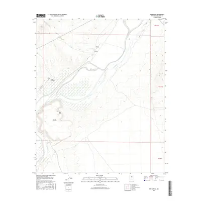
2017 Map of San Marcial
USGS Topo · Published 2017About this map
The Rio Grande dominates this arid landscape, winding through a wide floodplain between the dramatic elevations of Mesa del Contadero and the northern reaches of the Jornada del Muerto. This 2017 study illustrates the modern geography of San Marcial, a location shaped by its proximity to the river and the historic transport corridor of San Marcial Rd. The San Marcial Cem stands as a significant landmark for genealogists and local historians, anchoring the legacy of a community that has contended with the river's shifts over generations. To the north, the small settlement of Tiffany and the nearby Tiffany Canyon mark the transition into the rugged arroyo systems. Infrastructure like the San Antonio Ditch highlights the ongoing importance of water management in this high-desert environment, where the terrain rises sharply from the riverbank to the summit of Mesa Peak.
Find a feature on this map
13 named features on this map. Tap any name to fly to it.
Don’t see what you’re looking for? This feature index may not catch every label — zoom into the map to look around manually.
Map Details
Editions of this 2017 San Marcial Map
This is the sole edition of this map. No revisions or reprints were ever made.
Other maps of this area

1948 · San Antonio
USGS Topo · 1:62,500

1948 · Val Verde
USGS Topo · 1:62,500

1954 · Tularosa
USGS Topo · 1:250,000

1958 · Tularosa
USGS Topo · 1:250,000

1961 · Paraje Well
USGS Topo · 1:24,000

1961 · Fort Craig
USGS Topo · 1:24,000
1965 · Cienega Ranch
USGS Topo · 1:24,000

1979 · San Mateo Mountains
USGS Topo · 1:100,000
1981 · Indian Well Wilderness
USGS Topo · 1:24,000
1981 · Harriet Ranch
USGS Topo · 1:24,000