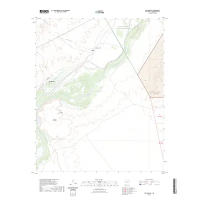
2023 Map of San Marcial
USGS Topo · Published 2023About this map
Rio Grande hydrology and the complex wetlands of the Bosque Del Apache National Wildlife Refuge dominate this part of the valley. The settlement of San Marcial and the nearby San Marcial Cem provide essential anchor points for genealogists and local historians tracing the heritage of this river corridor. To the east, the terrain shifts abruptly from the river bottom to the arid elevations of Mesa del Contadero and Mesa Peak.
Find a feature on this map
14 named features on this map. Tap any name to fly to it.
Don’t see what you’re looking for? This feature index may not catch every label — zoom into the map to look around manually.
Map Details
Editions of this 2023 San Marcial Map
This is the sole edition of this map. No revisions or reprints were ever made.
Other maps of this area

1948 · San Antonio
USGS Topo · 1:62,500

1948 · Val Verde
USGS Topo · 1:62,500

1954 · Tularosa
USGS Topo · 1:250,000

1958 · Tularosa
USGS Topo · 1:250,000

1961 · Paraje Well
USGS Topo · 1:24,000

1961 · Fort Craig
USGS Topo · 1:24,000
1965 · Cienega Ranch
USGS Topo · 1:24,000

1979 · San Mateo Mountains
USGS Topo · 1:100,000
1981 · Indian Well Wilderness
USGS Topo · 1:24,000
1981 · Harriet Ranch
USGS Topo · 1:24,000