1948 Map of San Marcos
USGS Topo · Published 1955About this map
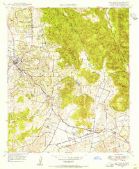
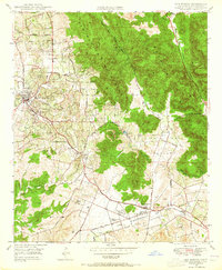
San Marcos Mountains and the Merriam Mountains dominate the northern landscape of this San Diego County quadrangle just after the war. The low-lying valleys are defined by the Atchison Topeka and Santa Fe railroad, which links the growing citrus and agricultural centers of Vista and San Marcos. Aviation history is prominent on this sheet, featuring the San Marcos Valley Airport and McCormick Airfield situated along Grand Ave. Education and community infrastructure are well-documented, from Palomar Junior College and High School to rural institutions like Richland Sch and Rich-mar Sch. The terrain is etched with numerous watercourses such as Agua Hedionda Creek and San Marcos Creek, while old property boundaries and local thoroughfares like Buena Road and Twin Oaks Road provide a clear view of the area's mid-century development.
Find a feature on this map
44 named features on this map. Tap any name to fly to it.
Don’t see what you’re looking for? This feature index may not catch every label — zoom into the map to look around manually.
Map Details
Editions of this 1948 San Marcos Map
2 editions found
Other maps of this area

1893 · Oceanside
USGS Topo · 1:62,500

1893 · Escondido
USGS Topo · 1:62,500

1898 · Oceanside
USGS Topo · 1:62,500

1901 · Escondido
USGS Topo · 1:62,500

1901 · Oceanside
USGS Topo · 1:62,500

1901 · San Luis Rey
USGS Topo · 1:125,000

1904 · Southern California Sheet No. 2
USGS Topo · 1:250,000

1941 · Margarita Peak
USGS Topo · 1:62,500

1942 · Margarita Peak
USGS Topo · 1:62,500

1942 · Temecula
USGS Topo · 1:62,500