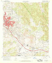
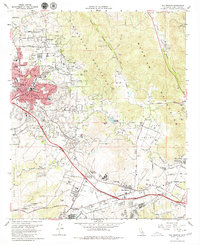
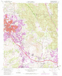
1968 Map of San Marcos
USGS Topo · Published 1970About this map
San Marcos Mountains dominate the central landscape of this late-1960s survey, illustrating the rapid transition of northern San Diego County from an agricultural and quarrying region into an educational and suburban corridor. The expanding city of Vista spreads across the western hills, while the community of San Marcos emerges to the southeast, anchored by Palomar College and several new schools like San Marcos High School. Critical infrastructure projects, such as the San Diego Aqueduct and the Pechstein Reservoir, highlight the engineering required to support this growth. In the valleys, industrial activity is still evident through several quarries and sand and gravel pits, while the Atchison Topeka and Santa Fe railroad provides the primary transportation spine through Los Vallecitos.
Find a feature on this map
44 named features on this map. Tap any name to fly to it.
Don’t see what you’re looking for? This feature index may not catch every label — zoom into the map to look around manually.
Map Details
Editions of this 1968 San Marcos Map
3 editions found
Other maps of this area

1893 · Oceanside
USGS Topo · 1:62,500

1893 · Escondido
USGS Topo · 1:62,500

1898 · Oceanside
USGS Topo · 1:62,500

1901 · Escondido
USGS Topo · 1:62,500

1901 · Oceanside
USGS Topo · 1:62,500

1901 · San Luis Rey
USGS Topo · 1:125,000

1904 · Southern California Sheet No. 2
USGS Topo · 1:250,000

1941 · Margarita Peak
USGS Topo · 1:62,500

1942 · Margarita Peak
USGS Topo · 1:62,500

1942 · Temecula
USGS Topo · 1:62,500