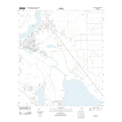
2012 Map of San Mateo
USGS Topo · Published 2012About this map
The Saint Johns River and Dunns Cr define the landscape of this river-bound region in eastern Florida. The settlement of San Mateo serves as the local hub, supported by a network of landings such as Piney Bluff Landing, Moccasin Landing, and Sykes Landing that dot the riverbanks. This 2012 survey illustrates the area's transition from the riverfront to the interior wetlands of Long Swamp, as well as the significant bodies of water to the south, including Crescent Lake and Lake Broward. For local historians and genealogists, the map preserves the location of Yelvington Cem and San Mateo Cem, alongside smaller settlements like Sutherlands Still. The presence of the Pomona Landing Airport near the southern boundary reflects the modern infrastructure integrated into this traditionally water-reliant landscape.
Find a feature on this map
132 named features on this map. Tap any name to fly to it.
Don’t see what you’re looking for? This feature index may not catch every label — zoom into the map to look around manually.
Map Details
Editions of this 2012 San Mateo Map
This is the sole edition of this map. No revisions or reprints were ever made.
Other maps of this area

1912 · Palatka
USGS Topo · 1:48,000

1915 · Palatka
USGS Topo · 1:62,500

1937 · Dinner Island
USGS Topo · 1:48,000

1943 · Dinner Island
USGS Topo · 1:62,500

1944 · Dinner Island
USGS Topo · 1:62,500

1954 · Daytona Beach
USGS Topo · 1:250,000

1958 · Daytona Beach
USGS Topo · 1:250,000

1964 · Daytona Beach
USGS Topo · 1:250,000
1968 · Satsuma
USGS Topo · 1:24,000
1968 · Palatka
USGS Topo · 1:24,000