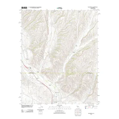
2012 Map of San Miguel
USGS Topo · Published 2012About this map
The Salinas River corridor defines the western edge of this landscape, where the settlement of San Miguel sits at the junction of modern infrastructure and the valley's drainage system. The area is characterized by a network of significant canyons, including Vineyard Canyon and Mahoney Canyon, which channel seasonal water from the eastern uplands toward the river. Transportation is anchored by the corridor of Us-101 S, which follows the historical path through McKay and past the agricultural flats of Indian Valley. Smaller settlements like Nacimiento are positioned near the river, while a system of rural roads such as Indian Valley Rd and Cross Canyons Rd provides access to the dissected terrain of Portuguese Canyon and Deer Canyon. The map reveals the relationship between the valley floor's development and the complex hydrography of creeks like Big Sandy Cr and San Jacinto Cr.
Find a feature on this map
21 named features on this map. Tap any name to fly to it.
Don’t see what you’re looking for? This feature index may not catch every label — zoom into the map to look around manually.
Map Details
Editions of this 2012 San Miguel Map
This is the sole edition of this map. No revisions or reprints were ever made.
Other maps of this area

1919 · San Miguel
USGS Topo · 1:62,500

1919 · Paso Robles
USGS Topo · 1:62,500

1919 · Bradley
USGS Topo · 1:62,500

1919 · Adelaida
USGS Topo · 1:62,500

1932 · Adelaida
USGS Topo · 1:62,500

1941 · Bradley
USGS Topo · 1:62,500

1942 · Adelaida
USGS Topo · 1:62,500

1943 · Paso Robles
USGS Topo · 1:62,500

1947 · San Luis Obispo
USGS Topo · 1:250,000

1947 · San Miguel
USGS Topo · 1:62,500