
1948 Map of San Onofre Bluff
USGS Topo · Published 1966About this map
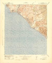
Camp Pendleton Naval Reservation dominates the coastal terrace of northern San Diego County in this mid-century portrait of the California shoreline. The landscape is defined by the sharp transition from the Gulf of Santa Catalina to the rising terrain of San Onofre Bluff. This stretch of coast serves as a critical transportation corridor, where the Atchison Topeka and Santa Fe railroad runs parallel to the Santa Fe Highway and the historic Route 101. The map captures the infrastructure of the era, showing the highway transitioning between four and six lanes near the small settlement of Agra. The topography reveals the deeply incised drainages typical of this marine terrace, illustrating the coastal geography before the extensive modern developments that would later characterize the region between San Clemente and Oceanside.
Find a feature on this map
11 named features on this map. Tap any name to fly to it.
Don’t see what you’re looking for? This feature index may not catch every label — zoom into the map to look around manually.
Map Details
Editions of this 1948 San Onofre Bluff Map
This is the sole edition of this map. No revisions or reprints were ever made.
Other maps of this area

1893 · Oceanside
USGS Topo · 1:62,500

1898 · Oceanside
USGS Topo · 1:62,500

1901 · Oceanside
USGS Topo · 1:62,500

1901 · San Luis Rey
USGS Topo · 1:125,000

1902 · Capistrano
USGS Topo · 1:125,000

1904 · Southern California Sheet No. 2
USGS Topo · 1:250,000

1906 · Capistrano
USGS Topo · 1:125,000

1941 · Margarita Peak
USGS Topo · 1:62,500

1942 · Margarita Peak
USGS Topo · 1:62,500
1942 · San Juan Capistrano
USGS Topo · 1:62,500
Featured Places
- San Clemente, CA
- Marine Corps Base Camp Pendleton, CA
- Agra, Marine Corps Base Camp Pendleton
- San Diego County, CA
- Orange County, CA