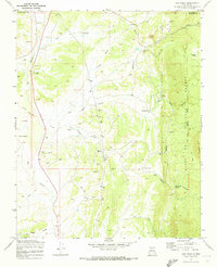
1970 Map of San Pablo
USGS Topo · Published 1973About this map
Industrial operations and high-desert ranching define this 1970s landscape on the edge of the Santa Fe National Forest. The northern reach of the sheet is dominated by the Nacimiento Mine, complete with a Tailings Pond and pipeline infrastructure, while the Señorito Mine and Padilla Mine are tucked into the drainages of Señorito Canyon and San Pablo Canyon. These extractive sites sit in contrast to small settlements and outposts like San Pablo and Lagunitas.
Find a feature on this map
29 named features on this map. Tap any name to fly to it.
Don’t see what you’re looking for? This feature index may not catch every label — zoom into the map to look around manually.
Map Details
Editions of this 1970 San Pablo Map
This is the sole edition of this map. No revisions or reprints were ever made.
Other maps of this area

1883 · Mt. Taylor
USGS Topo · 1:250,000

1886 · Mt. Taylor
USGS Topo · 1:250,000

1889 · Largo
USGS Topo · 1:250,000

1890 · Jemes
USGS Topo · 1:125,000

1892 · Jemes
USGS Topo · 1:125,000

1892 · Mt. Taylor
USGS Topo · 1:250,000

1895 · Largo
USGS Topo · 1:250,000

1899 · Mt. Taylor
USGS Topo · 1:250,000

1909 · Gallina
USGS Topo · 1:125,000

1939 · La Ventana
USGS Topo · 1:62,500