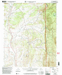
2002 Map of San Pablo
USGS Topo · Published 2003About this map
The high-desert terrain of Sandoval County meets the industrial footprint of the early 2000s, defined by the winding course of the Rio Puerco and the prominent rising of Marion Butte. This area shows a complex intersection of national forest land and extractive history, most notably at the Nacimiento Mine and Padilla Mine. The map details small settlements like San Pablo and San Miguel, which are connected by a network of drainage systems including San Pablo Canyon and San Miguel Canyon. Industrial infrastructure is visible through a Sawmill Incinerator and a remote Landing Strip, illustrating the economic activities that supported these communities. Further north, the landscape transitions toward the Santa Fe National Forest and the boundary with Rio Arriba County near Lagunitas, where the presence of a Sewage Disposal Ponds indicates local municipal utility management.
Find a feature on this map
27 named features on this map. Tap any name to fly to it.
Don’t see what you’re looking for? This feature index may not catch every label — zoom into the map to look around manually.
Map Details
Editions of this 2002 San Pablo Map
This is the sole edition of this map. No revisions or reprints were ever made.
Other maps of this area

1883 · Mt. Taylor
USGS Topo · 1:250,000

1886 · Mt. Taylor
USGS Topo · 1:250,000

1889 · Largo
USGS Topo · 1:250,000

1890 · Jemes
USGS Topo · 1:125,000

1892 · Jemes
USGS Topo · 1:125,000

1892 · Mt. Taylor
USGS Topo · 1:250,000

1895 · Largo
USGS Topo · 1:250,000

1899 · Mt. Taylor
USGS Topo · 1:250,000

1909 · Gallina
USGS Topo · 1:125,000

1939 · La Ventana
USGS Topo · 1:62,500