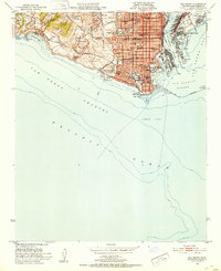
1951 Map of San Pedro
USGS Topo · Published 1953About this map
The coastal military installations and industrial harbor of San Pedro dominate the landscape in the early 1950s. Multiple reservations including Fort Mac Arthur, the Naval Reservation, and a Coast Guard Reservation underscore the area's strategic importance during the post-war era. The complex maritime infrastructure is evident in the Los Angeles Harbor and the San Pedro Channel, where a massive Breakwater protects the docks and the Terminal Island facilities, including the East San Pedro district.
Find a feature on this map
48 named features on this map. Tap any name to fly to it.
Don’t see what you’re looking for? This feature index may not catch every label — zoom into the map to look around manually.
Map Details
Editions of this 1951 San Pedro Map
2 editions found
Other maps of this area

1896 · Redondo
USGS Topo · 1:62,500

1896 · Las Bolsas
USGS Topo · 1:62,500

1896 · San Pedro
USGS Topo · 1:62,500

1896 · Downey
USGS Topo · 1:62,500

1899 · Downey
USGS Topo · 1:62,500

1901 · Southern California Sheet No. 1
USGS Topo · 1:250,000

1902 · Downey
USGS Topo · 1:62,500

1904 · Southern California Sheet No. 1
USGS Topo · 1:250,000

1923 · Wilmington
USGS Topo · 1:24,000
1925 · Wilmington
USGS Topo · 1:24,000
Featured Places
- Los Angeles, CA
- Rancho Palos Verdes, CA
- Rolling Hills, CA
- La Rambla, CA
- Portuguese Bend, Rancho Palos Verdes