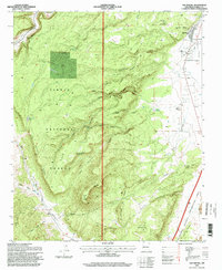
1995 Map of San Rafael
USGS Topo · Published 1998About this map
San Rafael sits at the eastern edge of the volcanic and canyon-carved terrain of Cibola National Forest in this mid-1990s revision. The map reveals a landscape defined by its water sources and heritage sites, including the Ojo de Gallo spring and the nearby Pumphouse. A network of canyons like Cow Canyon and Aqua Fria Canyon cut through the high mesas, while the presence of the Old Logging Chute near Zuni Canyon points to earlier industrial activity in the timber-rich highlands. Genealogists can identify the local Cemetery and the Porter Cemetery, while landmarks like Gallo Peak and Dead Hill provide orientation for those researching the complex topography. To the southeast, the boundary of the El Malpais National Conservation Area begins, marking the transition into the lava-influenced geography of the Zuni Mountains region.
Find a feature on this map
45 named features on this map. Tap any name to fly to it.
Don’t see what you’re looking for? This feature index may not catch every label — zoom into the map to look around manually.
Map Details
Editions of this 1995 San Rafael Map
This is the sole edition of this map. No revisions or reprints were ever made.
Other maps of this area

1883 · Mt. Taylor
USGS Topo · 1:250,000

1886 · Wingate
USGS Topo · 1:250,000

1886 · Mt. Taylor
USGS Topo · 1:250,000

1892 · Wingate
USGS Topo · 1:250,000

1892 · Mt. Taylor
USGS Topo · 1:250,000

1899 · Mt. Taylor
USGS Topo · 1:250,000

1917 · Broom Mountain
USGS Topo · 1:125,000

1951 · Mt Sedgwick
USGS Topo · 1:24,000

1952 · Paxton Springs
USGS Topo · 1:24,000

1954 · Saint Johns
USGS Topo · 1:250,000