1976 Map of San Simeon
USGS Topo · Published 1980About this map
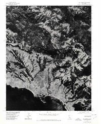
San Simeon sits at the threshold of the California coast in this orthophotoquad, which captures the intersection of ranching lands and the rugged Santa Lucia Range during the mid-1970s. The aerial imagery, produced in cooperation with the Soil Conservation Service, reveals a landscape defined by the winding course of Arroyo de la Cruz as it cuts through the coastal hills toward the Pacific Ocean. Inland, the high point of Burnett Peak overlooks a complex network of canyons and ridgelines. Because this is an orthophotograph rather than a traditional line map, it provides an unfiltered look at vegetation patterns, pasture boundaries, and the early footprint of the coastal settlement, offering researchers a clear view of land use before subsequent decades of development and conservation changes.
Find a feature on this map
4 named features on this map. Tap any name to fly to it.
Don’t see what you’re looking for? This feature index may not catch every label — zoom into the map to look around manually.
Map Details
Editions of this 1976 San Simeon Map
This is the sole edition of this map. No revisions or reprints were ever made.
Other maps of this area

1919 · Bryson
USGS Topo · 1:62,500

1919 · Piedras Blancas
USGS Topo · 1:62,500

1919 · San Simeon
USGS Topo · 1:62,500

1921 · Cape San Martin
USGS Topo · 1:62,500
1927 · Piedras Blancas
USGS Topo · 1:62,500
1937 · San Simeon
USGS Topo · 1:62,500

1941 · Cape San Martin
USGS Topo · 1:62,500

1941 · Bryson
USGS Topo · 1:62,500

1942 · Bryson
USGS Topo · 1:62,500

1942 · Cape San Martin
USGS Topo · 1:62,500