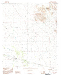
1987 Map of San Simon
USGS Topo · Published 1987About this map
San Simon sits at the heart of this desert landscape in Cochise County, where the infrastructure of agricultural and ranching life defines the terrain. The community is anchored by the San Simon River and a local Cotton Gin, alongside a Landing Strip and Rodeo Ground that speak to the varied utility of the land in the late twentieth century. A USDA Check Station further illustrates the significance of the area's transportation and commerce corridors. To the northeast, the valley floor gives way to prominent peaks and canyons. Mc Kenzie Peak and the benchmark at Gazelle 4963 overlook the drainage of Ward Canyon. Numerous water sources, such as Kings Well and Hat Top Tank, are scattered across the region, tracing the essential network of wells and tanks necessary for sustaining life and industry in this arid environment.
Find a feature on this map
15 named features on this map. Tap any name to fly to it.
Don’t see what you’re looking for? This feature index may not catch every label — zoom into the map to look around manually.
Map Details
Editions of this 1987 San Simon Map
This is the sole edition of this map. No revisions or reprints were ever made.
Other maps of this area

1917 · San Simon
USGS Topo · 1:125,000

1926 · Cochise Head
USGS Topo · 1:62,500

1926 · Orange Butte
USGS Topo · 1:62,500

1928 · Chenoweth
USGS Topo · 1:62,500

1928 · Bowie
USGS Topo · 1:62,500

1949 · Bowie
USGS Topo · 1:62,500

1950 · San Simon
USGS Topo · 1:62,500

1950 · Bowie
USGS Topo · 1:62,500

1950 · Cochise Head
USGS Topo · 1:62,500

1950 · Vanar
USGS Topo · 1:62,500