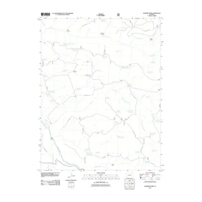
2011 Map of Sanborn Park
USGS Topo · Published 2011About this map
Sanborn Park serves as a central hub in this high-plateau landscape of Montrose County, where a complex network of water management features reveals the area's agricultural and industrial history. The presence of the McKeever Sawmill and several logging-related features, including Logging Camp Draw Reservoir and Logging Camp Spring, points to a legacy of timber harvesting. The terrain is deeply incised by drainage systems like Red Canyon and Little Red Canyon in the north, while the San Miguel River carves through the southwestern corner.
Find a feature on this map
54 named features on this map. Tap any name to fly to it.
Don’t see what you’re looking for? This feature index may not catch every label — zoom into the map to look around manually.
Map Details
Editions of this 2011 Sanborn Park Map
This is the sole edition of this map. No revisions or reprints were ever made.
Other maps of this area

1953 · Placerville
USGS Topo · 1:24,000

1956 · Moab
USGS Topo · 1:250,000

1959 · Moab
USGS Topo · 1:250,000

1960 · Moab
USGS Topo · 1:250,000

1962 · Moab
USGS Topo · 1:250,000

1964 · Moab
USGS Topo · 1:250,000
1964 · Norwood
USGS Topo · 1:24,000
1964 · Gurley Canyon
USGS Topo · 1:24,000
1964 · Oak Hill
USGS Topo · 1:24,000

1965 · Moab
USGS Topo · 1:250,000