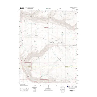
2013 Map of Sanborn Park
USGS Topo · Published 2013About this map
Sanborn Park defines the high-plateau landscape of western Colorado as it appeared in the early 21st century, dominated by a complex network of water management features and timber history. Within the Uncompahgre National Forest, the map reveals how the land was adapted for ranching and industry, from the Sanborn School and Mckeever Sawmill to the Flying M & M Ranch Airport. The topography is etched by dramatic cuts like Red Canyon and Little Red Canyon, which drain into the San Miguel River as it winds through San Miguel Canyon. Numerous man-made basins such as Tarantula Reservoir, Fisher Reservoir, and the Sorenson Reservoir illustrate the critical importance of water storage on Wrights Mesa and the surrounding Horsefly Bench. Historic routes like the Horsefly Trail and Co-145 provide the primary access through this high-altitude terrain.
Find a feature on this map
68 named features on this map. Tap any name to fly to it.
Don’t see what you’re looking for? This feature index may not catch every label — zoom into the map to look around manually.
Map Details
Editions of this 2013 Sanborn Park Map
This is the sole edition of this map. No revisions or reprints were ever made.
Other maps of this area

1953 · Placerville
USGS Topo · 1:24,000

1956 · Moab
USGS Topo · 1:250,000

1959 · Moab
USGS Topo · 1:250,000

1960 · Moab
USGS Topo · 1:250,000

1962 · Moab
USGS Topo · 1:250,000

1964 · Moab
USGS Topo · 1:250,000
1964 · Norwood
USGS Topo · 1:24,000
1964 · Gurley Canyon
USGS Topo · 1:24,000
1964 · Oak Hill
USGS Topo · 1:24,000

1965 · Moab
USGS Topo · 1:250,000