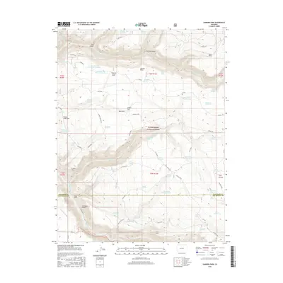
2016 Map of Sanborn Park
USGS Topo · Published 2016About this map
Sanborn School stands at the center of this high-altitude landscape, illustrating the remote educational infrastructure within the Uncompahgre National Forest during the mid-2010s. The terrain is defined by dramatic elevation changes, from the depths of San Miguel Canyon in the south to the expansive Horsefly Bench and Wrights Mesa further north. This area serves as a critical watershed, evidenced by an extensive network of man-made water management features including Tarantula Reservoir, Herman Reservoir, and the Nelson Ditch.
Find a feature on this map
62 named features on this map. Tap any name to fly to it.
Don’t see what you’re looking for? This feature index may not catch every label — zoom into the map to look around manually.
Map Details
Editions of this 2016 Sanborn Park Map
This is the sole edition of this map. No revisions or reprints were ever made.
Other maps of this area

1953 · Placerville
USGS Topo · 1:24,000

1956 · Moab
USGS Topo · 1:250,000

1959 · Moab
USGS Topo · 1:250,000

1960 · Moab
USGS Topo · 1:250,000

1962 · Moab
USGS Topo · 1:250,000

1964 · Moab
USGS Topo · 1:250,000
1964 · Norwood
USGS Topo · 1:24,000
1964 · Gurley Canyon
USGS Topo · 1:24,000
1964 · Oak Hill
USGS Topo · 1:24,000

1965 · Moab
USGS Topo · 1:250,000