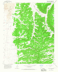
1964 Map of Sand Canyon
USGS Topo · Published 1967About this map
Cebollita Mesa dominates the eastern half of this landscape, rising above a network of drainages that includes Cebolla Creek and Sand Canyon. The map details a rugged transition from the volcanic flows of The Lava and Malpais in the northwest to the complex canyon systems of the southeast. Ranching and water management are the primary human imprints on this terrain, evidenced by the numerous named water sources such as Armijo Spring and a series of remote windmills including Henson No 1 Windmill, Indian Windmill, and Woods No 1 Windmill. To the east, the Acoma Indian Reservation boundary indicates the intersection of tribal lands and the public domain. The presence of Homestead Canyon and Armijo Canyon suggests the historical movement of settlers and seasonal livestock through these high-desert corridors during the mid-20th century.
Find a feature on this map
21 named features on this map. Tap any name to fly to it.
Don’t see what you’re looking for? This feature index may not catch every label — zoom into the map to look around manually.
Map Details
Editions of this 1964 Sand Canyon Map
This is the sole edition of this map. No revisions or reprints were ever made.
Other maps of this area

1917 · Broom Mountain
USGS Topo · 1:125,000

1954 · Saint Johns
USGS Topo · 1:250,000

1954 · Socorro
USGS Topo · 1:250,000

1957 · Saint Johns
USGS Topo · 1:250,000

1958 · Socorro
USGS Topo · 1:250,000

1958 · Saint Johns
USGS Topo · 1:250,000
1961 · North Pasture
USGS Topo · 1:24,000
1961 · Laguna Honda
USGS Topo · 1:24,000

1962 · Socorro
USGS Topo · 1:250,000

1962 · Saint Johns
USGS Topo · 1:250,000