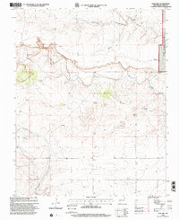
1998 Map of Sand Hill
USGS Topo · Published 2001About this map
Kiowa National Grassland dominates the northeastern corner of this Union County landscape, where the high plains meet the intricate drainage systems of the Canadian River basin. The terrain is defined by the carved paths of Carrizo Creek and Garcia Creek, which slice through the topography to create the prominent Cedar Hills and the namesake Sand Hill. This map reflects a ranching landscape reliant on groundwater, evidenced by a network of family-named or location-based landmarks such as Domingues Windmill, Means Windmill, and Sand Hill Windmill.
Find a feature on this map
17 named features on this map. Tap any name to fly to it.
Don’t see what you’re looking for? This feature index may not catch every label — zoom into the map to look around manually.
Map Details
Editions of this 1998 Sand Hill Map
This is the sole edition of this map. No revisions or reprints were ever made.
Other maps of this area

1954 · Dalhart
USGS Topo · 1:250,000

1958 · Dalhart
USGS Topo · 1:250,000

1962 · Dalhart
USGS Topo · 1:250,000

1966 · Royce
USGS Topo · 1:24,000

1966 · Black Canyon
USGS Topo · 1:24,000

1966 · Tate School
USGS Topo · 1:24,000

1966 · Clapham
USGS Topo · 1:24,000

1966 · Car Top Butte
USGS Topo · 1:24,000

1966 · Sand Hill
USGS Topo · 1:24,000

1970 · Clayton
USGS Topo · 1:24,000