
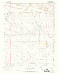
1966 Map of Royce
USGS Topo · Published 1966About this map
The Colorado and Southern railroad cuts a straight line across this high plains landscape of Union County, providing the primary infrastructure for the small community of Royce. Life in this mid-1960s cattle country centers around the essential management of water and livestock, evidenced by the numerous named landmarks such as McCook Windmill, Knolls Windmill, and Ham Windmill. The drainage network of Perico Creek and Rabbit Ear Creek defines the local topography, while localized extraction is noted at several Gravel Pits and a Quarry. For those researching family history in the region, the map identifies specific burial sites including Antioch Cem and Otto Cem, alongside established properties like Rockledge Ranch and Mays Ranch, offering a clear view of land use and habitation during this era.
Find a feature on this map
35 named features on this map. Tap any name to fly to it.
Don’t see what you’re looking for? This feature index may not catch every label — zoom into the map to look around manually.
Map Details
Editions of this 1966 Royce Map
2 editions found
Other maps of this area

1954 · Dalhart
USGS Topo · 1:250,000

1958 · Dalhart
USGS Topo · 1:250,000

1962 · Dalhart
USGS Topo · 1:250,000

1966 · Black Canyon
USGS Topo · 1:24,000

1966 · Tate School
USGS Topo · 1:24,000

1966 · Sand Hill
USGS Topo · 1:24,000

1970 · Clayton
USGS Topo · 1:24,000

1970 · Clayton SW
USGS Topo · 1:24,000

1972 · Mount Dora
USGS Topo · 1:24,000

1972 · Bible Top Butte
USGS Topo · 1:24,000