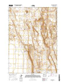
2017 Map of Sand Rock
USGS Topo · Published 2017About this map
Christmas Lake Valley and the expansive basin of Buffalo Flat define this high-desert landscape in northern Lake County. Published by the U.S. Geological Survey, the map details a region where topography is marked by volcanic and alluvial features such as Sand Rock and the elevated Pine Ridge. The transition from the valley floor to the surrounding heights is documented through 10-foot contour intervals, illustrating the subtle drainage patterns leading toward Hansen Valley.
Find a feature on this map
19 named features on this map. Tap any name to fly to it.
Don’t see what you’re looking for? This feature index may not catch every label — zoom into the map to look around manually.
Map Details
Editions of this 2017 Sand Rock Map
This is the sole edition of this map. No revisions or reprints were ever made.
Other maps of this area

1955 · Crescent
USGS Topo · 1:250,000

1957 · Crescent
USGS Topo · 1:250,000

1958 · Crescent
USGS Topo · 1:250,000

1970 · Crescent
USGS Topo · 1:250,000

1981 · Fossil Lake
USGS Topo · 1:24,000

1981 · Sand Rock
USGS Topo · 1:24,000

1981 · Moonlight Butte
USGS Topo · 1:24,000

1981 · Mean Rock Well
USGS Topo · 1:24,000

1981 · Elk Butte
USGS Topo · 1:24,000

1981 · Chicago Valley
USGS Topo · 1:24,000