
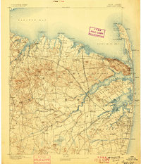
1893 Map of Sandy Hook
USGS Topo · Published 1893About this map
Sandy Hook and the northern reaches of Monmouth County are documented here during the late nineteenth century, a time of critical maritime and rail development. The map details a sophisticated network of navigational aids including Sandy Hook Light, the Navesink Lights, and multiple beacons like Conover Beacon that guided traffic into Raritan Bay and Sandy Hook Bay. Inland, the terrain rises toward the Highlands of Navesink and Telegraph Hill, while the coastal strip is dotted with Life Saving Stations, such as L.S.Station Seabright, highlighting the region's importance to coastal safety.
Find a feature on this map
123 named features on this map. Tap any name to fly to it.
Don’t see what you’re looking for? This feature index may not catch every label — zoom into the map to look around manually.
Map Details
Editions of this 1893 Sandy Hook Map
2 editions found
Other maps of this area

1888 · Plainfield
USGS Topo · 1:62,500

1888 · New Brunswick
USGS Topo · 1:62,500

1888 · Asbury Park
USGS Topo · 1:62,500

1888 · Cassville
USGS Topo · 1:62,500

1888 · Sandy Hook
USGS Topo · 1:62,500

1889 · Brooklyn
USGS Topo · 1:62,500

1891 · Brooklyn
USGS Topo · 1:62,500

1893 · New Brunswick
USGS Topo · 1:62,500

1893 · Plainfield
USGS Topo · 1:62,500

1893 · Asbury Park
USGS Topo · 1:62,500