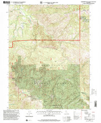
1996 Map of Sanhedrin Mountain
USGS Topo · Published 2001About this map
Sanhedrin Mountain dominates this mid-1990s survey of the California Coast Ranges, a landscape defined by sharp elevation shifts and an intricate network of seasonal and perennial drainages. Located at the intersection of the Mendocino Co Lake Co line, the map illustrates a managed wilderness where early ranching footprints like Elk Creek Ranch and Crocker Place persist alongside fire-prevention infrastructure at the Sanhedrin Lookout. The terrain is characterized by prominent ridges such as Long Doe Ridge and the aptly named Impassable Rock, which drop into the deep canyons of Elk Creek and Sanhedrin Creek. Small, high-elevation water bodies like Lily Pad Lake and Summit Lake provide rare aquatic features within the Mendocino National Forest, while numerous named springs like Vulture Spring and Four Pines Spring mark the hydrological focal points of the backcountry.
Find a feature on this map
37 named features on this map. Tap any name to fly to it.
Don’t see what you’re looking for? This feature index may not catch every label — zoom into the map to look around manually.
Map Details
Editions of this 1996 Sanhedrin Mountain Map
This is the sole edition of this map. No revisions or reprints were ever made.
Other maps of this area

1922 · Hullville
USGS Topo · 1:62,500

1929 · Eden Valley
USGS Topo · 1:62,500

1943 · Pomo
USGS Topo · 1:62,500

1951 · Lake Pillsbury
USGS Topo · 1:62,500

1952 · Hull Mountain
USGS Topo · 1:62,500

1952 · Eden Valley
USGS Topo · 1:62,500

1957 · Ukiah
USGS Topo · 1:250,000

1960 · Ukiah
USGS Topo · 1:250,000

1960 · Potter Valley
USGS Topo · 1:62,500
1966 · Sanhedrin Mtn
USGS Topo · 1:24,000