
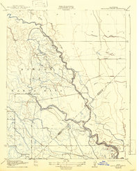
1922 Map of Santa Rita Bridge
USGS Topo · Published 1922About this map
San Joaquin River and its intricate network of sloughs define this Central Valley landscape as it was surveyed by N.E. Ballmer and Roscoe Reeves in 1916. The map reveals an era when large landholdings and irrigation interests shaped the terrain, featuring the extensive Santa Rita Ranch and Lucerne Farm. The confluence of the Chowchilla River and the braided channels of Sand Slough and Wood Slough demonstrate the complex hydrology of the valley floor before modern water management.
Find a feature on this map
22 named features on this map. Tap any name to fly to it.
Don’t see what you’re looking for? This feature index may not catch every label — zoom into the map to look around manually.
Map Details
Editions of this 1922 Santa Rita Bridge Map
2 editions found
Other maps of this area

1913 · Panoche
USGS Topo · 1:125,000

1916 · Santa Rita Bridge
USGS Topo · 1:24,000

1916 · Delta Ranch
USGS Topo · 1:24,000

1918 · Bliss Ranch
USGS Topo · 1:31,680

1918 · Lingard
USGS Topo · 1:31,680

1918 · Sandy Mush
USGS Topo · 1:31,680

1918 · Turner Ranch
USGS Topo · 1:31,680

1920 · Santa Rita Bridge
USGS Topo · 1:31,680

1922 · Oxalis
USGS Topo · 1:31,680

1922 · Dos Palos
USGS Topo · 1:31,680