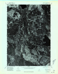
1975 Map of Saponac NW
USGS Topo · Published 1980About this map
The Passadumkeag River meanders through the dense woodlands of Penobscot County in this mid-1970s orthophotoquad. This aerial perspective, captured in October 1975, reveals the heavy forest cover and natural drainage patterns of the region prior to later development or modern timber management. Along the eastern edge of the quadrangle, Saponac Pond serves as a prominent water feature, while the surrounding landscape is defined by unnamed peaks such as the one marked simply as Mtn. The map provides a raw visual record of the winding river corridor and the sparse road network that penetrated this timber-rich interior. It offers a clear view of the natural clearing and land use patterns that were present in this portion of Maine during the latter half of the twentieth century.
Find a feature on this map
3 named features on this map. Tap any name to fly to it.
Don’t see what you’re looking for? This feature index may not catch every label — zoom into the map to look around manually.
Map Details
Editions of this 1975 Saponac NW Map
This is the sole edition of this map. No revisions or reprints were ever made.
Other maps of this area

1917 · Passadumkeag
USGS Topo · 1:62,500

1920 · Winn
USGS Topo · 1:62,500

1931 · Saponac
USGS Topo · 1:48,000

1934 · Saponac
USGS Topo · 1:62,500

1942 · Lincoln
USGS Topo · 1:62,500

1954 · Millinocket
USGS Topo · 1:250,000

1957 · Lincoln
USGS Topo · 1:62,500

1957 · Saponac
USGS Topo · 1:62,500

1958 · Millinocket
USGS Topo · 1:250,000

1960 · Millinocket
USGS Topo · 1:250,000