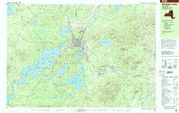
1999 Map of Saranac Lake
USGS Topo · Published 2001About this map
The village of Saranac Lake serves as the central hub of this late-20th-century Adirondack landscape, where the Saranac River flows into Lake Flower. This period records a village with deep-rooted community institutions like St Bernards Ch, Pine Ridge Cem, and North Country Community College. The transition from the historic sanitarium era toward modern recreation and state facilities is evident, with the Adirondack Educational Center and the Olympic Village near Ray Brook appearing alongside the Correctional Institution.
Find a feature on this map
89 named features on this map. Tap any name to fly to it.
Don’t see what you’re looking for? This feature index may not catch every label — zoom into the map to look around manually.
Map Details
Editions of this 1999 Saranac Lake Map
This is the sole edition of this map. No revisions or reprints were ever made.
Other maps of this area

1895 · Mt. Marcy
USGS Topo · 1:62,500

1896 · Lake Placid
USGS Topo · 1:62,500

1898 · Lake Placid
USGS Topo · 1:62,500

1902 · Mt. Marcy
USGS Topo · 1:62,500

1902 · Saranac
USGS Topo · 1:62,500

1904 · Saranac
USGS Topo · 1:62,500

1904 · Santanoni
USGS Topo · 1:62,500

1904 · Long Lake
USGS Topo · 1:62,500

1905 · Saint Regis
USGS Topo · 1:62,500

1948 · Ogdensburg
USGS Topo · 1:250,000