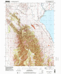
1997 Map of Saratoga Springs
USGS Topo · Published 2001About this map
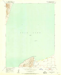
Saratoga Springs occupies the northeastern edge of this late-twentieth-century study, where the Jordan River flows from the northern tip of Utah Lake. The landscape is defined by the sharp contrast between the irrigated agricultural and developing lands along the lake shore and the high elevations of the Lake Mountains to the west. Water management is central to the area's layout, evidenced by the Provo Reservoir Canal and the Utah Lake Distributing Canal following the terrain contours. Cultural history is anchored by the Dugout Pony Express Station (Site) and a Historical Monument near the Salt Lake Meridian. Industrial activity is visible through several Open Pit Mine sites and a Gravel Pit, while the Utah Railroad corridor skirts the northern foothills near Tickville and the West Wash.
Find a feature on this map
33 named features on this map. Tap any name to fly to it.
Don’t see what you’re looking for? This feature index may not catch every label — zoom into the map to look around manually.
Map Details
Editions of this 1997 Saratoga Springs Map
This is the sole edition of this map. No revisions or reprints were ever made.
Other maps of this area

1885 · Salt Lake
USGS Topo · 1:250,000

1885 · Tooele Valley
USGS Topo · 1:250,000

1915 · Fairfield
USGS Topo · 1:62,500

1917 · Fairfield
USGS Topo · 1:62,500

1947 · Fivemile Pass
USGS Topo · 1:62,500
1947 · Goshen Pass
USGS Topo · 1:24,000

1949 · Goshen Pass
USGS Topo · 1:24,000
1950 · Soldiers Pass
USGS Topo · 1:24,000
1950 · Pelican Point
USGS Topo · 1:24,000
1950 · Lincoln Point
USGS Topo · 1:24,000