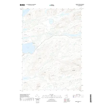
2019 Map of Sargent Ponds
USGS Topo · Published 2019About this map
Raquette Lake and its intricate shoreline dominate the northwestern reach of this Adirondack landscape, where water and wood define the historical geography. The Marion River serves as a vital hydrologic link, flowing through a series of significant water bodies including Utowana Lake and the eponymous Lower, Middle, and Upper Ponds. This topography of interconnected waterways historically facilitated the movement of people and timber through the central highlands of Hamilton County. High peaks such as Estelle Mtn and Speculator rise sharply above the drainages, marking a transition toward the higher ridges of the Blue Ridge. To the south, Sagamore Lake sits tucked away near Killkare Rd, reflecting a landscape of early 20th-century estate development and private wilderness retreats. The map provides a clear picture of the primitive road network, including Burkes Rd, which connects isolated shoreline points like Silver Beach and Woods Point to the broader region.
Find a feature on this map
36 named features on this map. Tap any name to fly to it.
Don’t see what you’re looking for? This feature index may not catch every label — zoom into the map to look around manually.
Map Details
Editions of this 2019 Sargent Ponds Map
This is the sole edition of this map. No revisions or reprints were ever made.
Other maps of this area

1899 · Indian Lake
USGS Topo · 1:62,500

1900 · Canada Lake
USGS Topo · 1:62,500

1902 · Indian Lake
USGS Topo · 1:62,500

1903 · West Canada Lakes
USGS Topo · 1:62,500

1903 · Raquette Lake
USGS Topo · 1:62,500

1903 · Blue Mountain
USGS Topo · 1:62,500

1950 · Utica
USGS Topo · 1:250,000

1954 · Blue Mountain
USGS Topo · 1:62,500

1954 · Indian Lake
USGS Topo · 1:62,500

1954 · West Canada Lakes
USGS Topo · 1:62,500