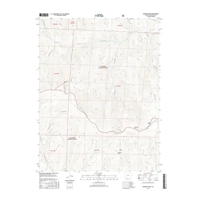
2016 Map of Sargents Mesa
USGS Topo · Published 2016About this map
The Continental Divide winds through this high-altitude landscape of Saguache County, forming the boundary between the Gunnison National Forest to the north and the Rio Grande National Forest to the south. The area is dominated by the broad summit of Sargents Mesa and the peak of Baldy, where several alpine drainage systems originate, including Dutchman Cr and Big Bend Cr. This 2016 survey documents a complex network of backcountry routes, such as the Continental Divide National Scenic Trail and the Baldy Lake Trail, which provides access to the remote waters of Baldy Lake. The terrain is characterized by high meadows like Firebox Park and deep drainages such as Houghland Gulch, reflecting the wilderness character of the Southern Rockies at the start of the twenty-first century.
Find a feature on this map
41 named features on this map. Tap any name to fly to it.
Don’t see what you’re looking for? This feature index may not catch every label — zoom into the map to look around manually.
Map Details
Editions of this 2016 Sargents Mesa Map
This is the sole edition of this map. No revisions or reprints were ever made.
Other maps of this area

1956 · Montrose
USGS Topo · 1:250,000

1959 · Montrose
USGS Topo · 1:250,000

1960 · Montrose
USGS Topo · 1:250,000

1962 · Doyleville
USGS Topo · 1:24,000

1962 · West Baldy
USGS Topo · 1:24,000

1964 · Sargents
USGS Topo · 1:24,000
1967 · North Pass
USGS Topo · 1:24,000

1967 · Sargents Mesa
USGS Topo · 1:24,000

1967 · Trickle Mountain
USGS Topo · 1:24,000

1967 · Lake Mountain NE
USGS Topo · 1:24,000