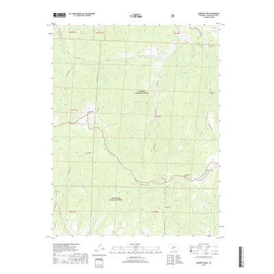
2019 Map of Sargents Mesa
USGS Topo · Published 2019About this map
The Continental Divide National Scenic Trail winds through this high-altitude landscape, marking the boundary between the Gunnison National Forest and the Rio Grande National Forest. Dominating the southeastern quadrant, Sargents Mesa stands as a prominent topographical feature near the headwaters of numerous mountain streams. This 2019 survey documents the complex drainage systems that feed into the larger regional basins, including the W Fork Long Br Tomichi Cr and Dutchman Creek.
Find a feature on this map
43 named features on this map. Tap any name to fly to it.
Don’t see what you’re looking for? This feature index may not catch every label — zoom into the map to look around manually.
Map Details
Editions of this 2019 Sargents Mesa Map
This is the sole edition of this map. No revisions or reprints were ever made.
Other maps of this area

1956 · Montrose
USGS Topo · 1:250,000

1959 · Montrose
USGS Topo · 1:250,000

1960 · Montrose
USGS Topo · 1:250,000

1962 · Doyleville
USGS Topo · 1:24,000

1962 · West Baldy
USGS Topo · 1:24,000

1964 · Sargents
USGS Topo · 1:24,000
1967 · North Pass
USGS Topo · 1:24,000

1967 · Sargents Mesa
USGS Topo · 1:24,000

1967 · Trickle Mountain
USGS Topo · 1:24,000

1967 · Lake Mountain NE
USGS Topo · 1:24,000