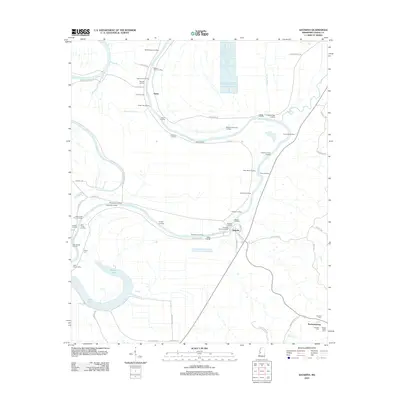
2012 Map of Satartia
USGS Topo · Published 2012About this map
Satartia and the small community of Enola anchor this survey of the Yazoo River floodplain, where a dense network of historic landings once served as the primary transit points for cotton and commerce. The map documents numerous riverfront sites including Liverpool Landing, Wilson and Screws Landing, and Sestos Landing, reflecting an era of heavy reliance on the Yazoo River for regional connectivity. Away from the riverbanks, the terrain is defined by low-lying wetlands and oxbows such as Dump Lake and Potato Hill Bayou. Local genealogy is well-served by the inclusion of several family and community burial grounds, including Henry Cem in the west and a cluster of sites near Mechanicsburg, such as Hamblin Cem and Mount Olivet Cem. This spatial arrangement of landings and cemeteries reveals the settlement patterns of a landscape shaped by both the river's path and agricultural development.
Find a feature on this map
67 named features on this map. Tap any name to fly to it.
Don’t see what you’re looking for? This feature index may not catch every label — zoom into the map to look around manually.
Map Details
Editions of this 2012 Satartia Map
This is the sole edition of this map. No revisions or reprints were ever made.
Other maps of this area

1940 · Mechanicsburg
USGS Topo · 1:62,500

1955 · Jackson
USGS Topo · 1:250,000

1961 · Jackson
USGS Topo · 1:250,000

1961 · Bayland
USGS Topo · 1:62,500

1961 · Valley
USGS Topo · 1:62,500

1962 · Jackson
USGS Topo · 1:250,000

1962 · Flora
USGS Topo · 1:62,500

1963 · Mechanicsburg
USGS Topo · 1:62,500

1984 · Yazoo City
USGS Topo · 1:100,000
1988 · Lucre
USGS Topo · 1:24,000