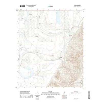
2018 Map of Satartia
USGS Topo · Published 2018About this map
The Yazoo River serpentines through this landscape, marking the transition between the flat delta lands and the rising terrain of Potters Ridge. The settlement of Satartia sits at a strategic point where the bluffs meet the river, with its grid of streets including Plum St and Richards Ave tucked against the winding waterway. To the southeast, Mechanicsburg occupies the higher ground, surrounded by several family and community burial sites including McLeod Cem, Mount Olivet Cem, and Hamblin Cem. This area demonstrates a classic Mississippi settlement pattern, where infrastructure like Satartia Rd and River Rd follows the natural levees and ridges to avoid the seasonally wet lowlands near Dump Lake and Potato Hill Bayou.
Find a feature on this map
39 named features on this map. Tap any name to fly to it.
Don’t see what you’re looking for? This feature index may not catch every label — zoom into the map to look around manually.
Map Details
Editions of this 2018 Satartia Map
This is the sole edition of this map. No revisions or reprints were ever made.
Other maps of this area

1940 · Mechanicsburg
USGS Topo · 1:62,500

1955 · Jackson
USGS Topo · 1:250,000

1961 · Jackson
USGS Topo · 1:250,000

1961 · Bayland
USGS Topo · 1:62,500

1961 · Valley
USGS Topo · 1:62,500

1962 · Jackson
USGS Topo · 1:250,000

1962 · Flora
USGS Topo · 1:62,500

1963 · Mechanicsburg
USGS Topo · 1:62,500

1984 · Yazoo City
USGS Topo · 1:100,000
1988 · Lucre
USGS Topo · 1:24,000