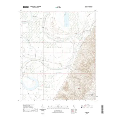
2020 Map of Satartia
USGS Topo · Published 2020About this map
The Yazoo River defines the landscape of this Yazoo County region, carving deep meanders through the alluvial plain. The village of Satartia sits at a prominent bend in the river, serving as a focal point where the flat delta lands meet the rising loess bluffs to the east. This transition in geography is marked by the shift from the broad basin of Dump Lake and Potato Hill Bayou to the dissected hills around Mechanicsburg. For family historians, several burial sites are documented across these diverse terrains, including Mount Olivet Cem and Hamblin Cem near the southern boundary, as well as the more isolated Henry Cem. The road network, including Satartia Rd and River Rd, follows the natural levees and ridges, illustrating how the river's path has historically dictated settlement patterns and transport in the Mississippi Delta.
Find a feature on this map
38 named features on this map. Tap any name to fly to it.
Don’t see what you’re looking for? This feature index may not catch every label — zoom into the map to look around manually.
Map Details
Editions of this 2020 Satartia Map
This is the sole edition of this map. No revisions or reprints were ever made.
Other maps of this area

1940 · Mechanicsburg
USGS Topo · 1:62,500

1955 · Jackson
USGS Topo · 1:250,000

1961 · Jackson
USGS Topo · 1:250,000

1961 · Bayland
USGS Topo · 1:62,500

1961 · Valley
USGS Topo · 1:62,500

1962 · Jackson
USGS Topo · 1:250,000

1962 · Flora
USGS Topo · 1:62,500

1963 · Mechanicsburg
USGS Topo · 1:62,500

1984 · Yazoo City
USGS Topo · 1:100,000
1988 · Lucre
USGS Topo · 1:24,000