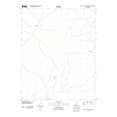
2010 Map of Sauble Circle Dot Ranch
USGS Topo · Published 2010About this map
Sauble Circle Dot Ranch serves as a primary landmark in this ranching landscape of Colfax County, defined by its sparse settlement and expansive drainage networks. The terrain is marked by the presence of Rio del Plano and Chico Creek, which carve through the high plains. Between these watercourses, the Jumping Divide creates a prominent topographical boundary. Local history is anchored by several family-named locations such as the Gillespie Ranch and the settlement of Gillespie to the south, along with the Langly Ranch to the east. Transportation through this open country relies on a handful of thoroughfares, including County Road C-34 and Chico Rd, reflecting the enduring rural character and spatial organization of New Mexico’s northeastern cattle country in the early 21st century.
Find a feature on this map
9 named features on this map. Tap any name to fly to it.
Don’t see what you’re looking for? This feature index may not catch every label — zoom into the map to look around manually.
Map Details
Editions of this 2010 Sauble Circle Dot Ranch Map
This is the sole edition of this map. No revisions or reprints were ever made.
Other maps of this area

1954 · Raton
USGS Topo · 1:250,000

1958 · Raton
USGS Topo · 1:250,000

1965 · Sauble Circle Dot Ranch
USGS Topo · 1:24,000

1965 · Abbott NW
USGS Topo · 1:24,000

1965 · Taylor Springs
USGS Topo · 1:24,000

1965 · Abbott
USGS Topo · 1:24,000

1971 · Tres Hermanos Peak
USGS Topo · 1:24,000
1971 · Loco Arroyo
USGS Topo · 1:24,000

1971 · Pine Buttes
USGS Topo · 1:24,000

1974 · Point Of Rocks Mesa
USGS Topo · 1:24,000