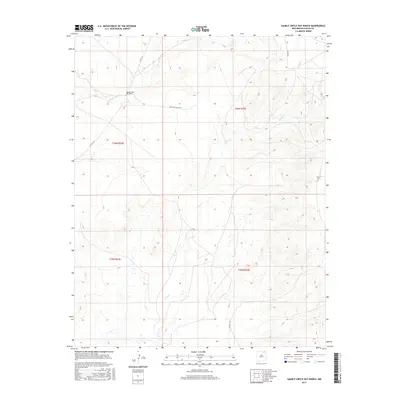
2017 Map of Sauble Circle Dot Ranch
USGS Topo · Published 2017About this map
Sauble Circle Dot Ranch serves as a primary geographic anchor in this section of Colfax County, where the high plains are carved by subtle drainage networks. The landscape is defined by the winding course of the Rio del Plano in the northwest and Chico Cr, which snakes through the central and southern portions of the quadrangle. This 2017 survey reflects the enduring ranching character of northeastern New Mexico, where large landholdings are connected by a sparse network of county roads. The road system, including Co Rd C-34 and the eponymous Circle Dot Ranch Rd, follows the natural contours of the terrain rather than a strict grid, illustrating how historical land use and water access continue to dictate the placement of local infrastructure in this part of the state.
Find a feature on this map
12 named features on this map. Tap any name to fly to it.
Don’t see what you’re looking for? This feature index may not catch every label — zoom into the map to look around manually.
Map Details
Editions of this 2017 Sauble Circle Dot Ranch Map
This is the sole edition of this map. No revisions or reprints were ever made.
Other maps of this area

1954 · Raton
USGS Topo · 1:250,000

1958 · Raton
USGS Topo · 1:250,000

1965 · Sauble Circle Dot Ranch
USGS Topo · 1:24,000

1965 · Abbott NW
USGS Topo · 1:24,000

1965 · Taylor Springs
USGS Topo · 1:24,000

1965 · Abbott
USGS Topo · 1:24,000

1971 · Tres Hermanos Peak
USGS Topo · 1:24,000
1971 · Loco Arroyo
USGS Topo · 1:24,000

1971 · Pine Buttes
USGS Topo · 1:24,000

1974 · Point Of Rocks Mesa
USGS Topo · 1:24,000