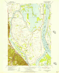
1954 Map of Sauvie Island
USGS Topo · Published 1956About this map
Sauvie Island emerges as a complex landscape of alluvial plains and managed waterways in the mid-1950s, defined by its position at the confluence of the Columbia River and the Willamette River. The interior of the island is dominated by the expansive Sturgeon Lake and a network of sloughs such as Marquam Slough and Ash Slough, which are bounded by an extensive system of levees. On the island's western edge, the Multnomah Channel separates the lowlands from the rising slopes of the Tualatin Mountains. Transport and industry are concentrated along this corridor, where the Spokane Portland and Seattle RR serves riverside settlements like Burlington and Rafton. The map documents the rural infrastructure of the era, including the Sauvie Island School and several landings such as Chapman Landing, which highlight the area's historical reliance on river-based commerce and agriculture.
Find a feature on this map
60 named features on this map. Tap any name to fly to it.
Don’t see what you’re looking for? This feature index may not catch every label — zoom into the map to look around manually.
Map Details
Editions of this 1954 Sauvie Island Map
This is the sole edition of this map. No revisions or reprints were ever made.
Other maps of this area

1897 · Portland
USGS Topo · 1:62,500

1905 · Portland
USGS Topo · 1:62,500

1915 · Hillsboro
USGS Topo · 1:62,500

1918 · Hillsboro
USGS Topo · 1:62,500

1922 · St. Helens
USGS Topo · 1:62,500

1940 · Hillsboro
USGS Topo · 1:62,500

1940 · Portland
USGS Topo · 1:62,500

1940 · La Center
USGS Topo · 1:62,500

1941 · St Helens
USGS Topo · 1:62,500

1943 · St Helens
USGS Topo · 1:62,500