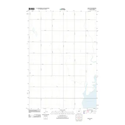
2012 Map of Savo SE
USGS Topo · Published 2012About this map
The low-lying hydrology of Brown County dominates this landscape, where the Mud Lake Reservoir and Columbia Road Reservoir gather water in a shallow drainage basin. These reservoirs, part of the James River watershed, reflect the modern water management efforts in this part of South Dakota. The surrounding terrain is organized by a strict cardinal grid of rural roads, including 393rd Ave and 397th Ave, typical of the Section Land system. While largely open and agricultural, the map reveals the subtle elevation changes near the water bodies, defined by a network of numbered section lines such as 106th St and 110th St. This 2012 survey by the U.S. Geological Survey provides a precise view of the rural infrastructure and prairie wetlands just after the turn of the twenty-first century.
Find a feature on this map
15 named features on this map. Tap any name to fly to it.
Don’t see what you’re looking for? This feature index may not catch every label — zoom into the map to look around manually.
Map Details
Editions of this 2012 Savo SE Map
This is the sole edition of this map. No revisions or reprints were ever made.
Other maps of this area

1894 · Hecla
USGS Topo · 1:62,500

1894 · Columbia
USGS Topo · 1:62,500

1894 · Savo
USGS Topo · 1:62,500

1896 · Columbia
USGS Topo · 1:125,000

1952 · Columbia NE
USGS Topo · 1:24,000

1952 · Westport
USGS Topo · 1:24,000

1953 · Savo SW
USGS Topo · 1:24,000

1953 · Houghton
USGS Topo · 1:24,000
1953 · Savo SE
USGS Topo · 1:24,000

1954 · Daly Corners
USGS Topo · 1:24,000
Featured Places
- Savo Township, SD
- Greenfield Township, SD
- Brainard Township, SD
- Shelby Township, SD
- Richland Township, SD