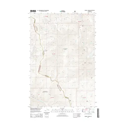
2014 Map of Sawmill Saddle
USGS Topo · Published 2014About this map
Bitterroot National Forest and Lolo National Forest converge in this high-altitude landscape along the border of Ravalli and Granite Counties. The terrain is defined by a dense network of drainages and named summits, including the prominent Green Mtn and the topographic high point at Eagle Point. Waterways such as the Burnt-Fork Bitterroot River and Rock Creek carve through the deep gulches, while Sawmill Saddle serves as a key crossing point between watersheds. The map documents a classic wilderness environment where few roads penetrate, with S Burnt Fork Rd providing one of the limited access routes into the southern portion of the area. Local history is traced through the names of various drainages like Grizzly Cr and Sawmill Cr, which reflect the region's logging and wildlife heritage.
Find a feature on this map
33 named features on this map. Tap any name to fly to it.
Don’t see what you’re looking for? This feature index may not catch every label — zoom into the map to look around manually.
Map Details
Editions of this 2014 Sawmill Saddle Map
This is the sole edition of this map. No revisions or reprints were ever made.
Other maps of this area

1903 · Bonner
USGS Topo · 1:125,000

1909 · Sapphire
USGS Topo · 1:125,000

1947 · Butte
USGS Topo · 1:250,000

1958 · Butte
USGS Topo · 1:250,000

1959 · Cleveland Mountain
USGS Topo · 1:62,500

1959 · Ravenna
USGS Topo · 1:62,500

1960 · Butte
USGS Topo · 1:250,000

1962 · Butte
USGS Topo · 1:250,000

1971 · Stony Creek
USGS Topo · 1:24,000
1974 · Stony Creek
USGS Topo · 1:24,000