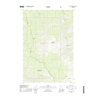
2020 Map of Sawmill Saddle
USGS Topo · Published 2020About this map
The Bitterroot-Rock Creek Divide serves as the primary geographical spine of this high-altitude landscape, marking the boundary between Ravalli Co and Granite Co. This 2020 survey documents a section of the Northern Rockies where the Lolo National Forest and Bitterroot National Forest meet. The terrain is defined by a dense network of drainages including Alder Cr and Rock Creek, which cut deep through the surrounding peaks. High points such as Many Horse Peak and Green Mtn provide significant landmarks for navigation within these protected lands. Evidence of human passage is found in the few forest access points like Miller Gulch Rd and the titular Sawmill Saddle, a strategic pass in the high country. The map also captures the headwaters of the Burnt Fork Bitterroot River, illustrating the vital water resources that flow from these mountains.
Find a feature on this map
38 named features on this map. Tap any name to fly to it.
Don’t see what you’re looking for? This feature index may not catch every label — zoom into the map to look around manually.
Map Details
Editions of this 2020 Sawmill Saddle Map
This is the sole edition of this map. No revisions or reprints were ever made.
Other maps of this area

1903 · Bonner
USGS Topo · 1:125,000

1909 · Sapphire
USGS Topo · 1:125,000

1947 · Butte
USGS Topo · 1:250,000

1958 · Butte
USGS Topo · 1:250,000

1959 · Cleveland Mountain
USGS Topo · 1:62,500

1959 · Ravenna
USGS Topo · 1:62,500

1960 · Butte
USGS Topo · 1:250,000

1962 · Butte
USGS Topo · 1:250,000

1971 · Stony Creek
USGS Topo · 1:24,000
1974 · Stony Creek
USGS Topo · 1:24,000