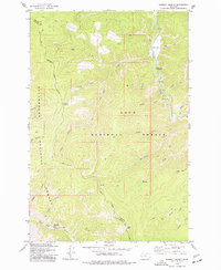
1974 Map of Sawmill Saddle
USGS Topo · Published 1977About this map
Bitterroot National Forest and Lolo National Forest converge in this mid-1970s survey, marking a rugged wilderness defined by deep canyons and steep ridgelines along the boundary of Granite and Ravalli counties. The terrain is shaped by an intricate network of waterways, including the winding Rock Creek to the east and the Burnt Fork Bitterroot River at the southern edge. Extensive pack trails and unpaved roads provide the only access to landmarks like Sawmill Saddle and high points such as Eagle Point and Green Mountain.
Find a feature on this map
31 named features on this map. Tap any name to fly to it.
Don’t see what you’re looking for? This feature index may not catch every label — zoom into the map to look around manually.
Map Details
Editions of this 1974 Sawmill Saddle Map
This is the sole edition of this map. No revisions or reprints were ever made.
Other maps of this area

1903 · Bonner
USGS Topo · 1:125,000

1909 · Sapphire
USGS Topo · 1:125,000

1947 · Butte
USGS Topo · 1:250,000

1958 · Butte
USGS Topo · 1:250,000

1959 · Cleveland Mountain
USGS Topo · 1:62,500

1959 · Ravenna
USGS Topo · 1:62,500

1960 · Butte
USGS Topo · 1:250,000

1962 · Butte
USGS Topo · 1:250,000

1971 · Stony Creek
USGS Topo · 1:24,000
1974 · Stony Creek
USGS Topo · 1:24,000