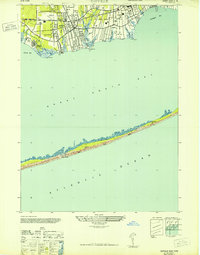
1947 Map of Sayville
USGS Topo · Published 1947About this map
The coastal landscape of Long Island's South Shore is captured here at a time of established maritime character and expanding seasonal recreation. Stretching from Oakdale through Sayville and Blue Point, the mainland is defined by a dense network of creeks, including Greens Brook and Namkee Creek, which feed into Great South Bay. The Long Island (Montauk Division) railroad provides the primary inland artery, while institutions like the LaSalle Military Academy and USCAA Radio Sta signal the area's social and communication importance.
Find a feature on this map
29 named features on this map. Tap any name to fly to it.
Don’t see what you’re looking for? This feature index may not catch every label — zoom into the map to look around manually.
Map Details
Editions of this 1947 Sayville Map
This is the sole edition of this map. No revisions or reprints were ever made.
Other maps of this area

1902 · Setauket
USGS Topo · 1:62,500

1902 · Fire Island
USGS Topo · 1:62,500

1903 · Fire Island
USGS Topo · 1:62,500

1904 · Setauket
USGS Topo · 1:62,500

1904 · Islip
USGS Topo · 1:125,000

1904 · Moriches
USGS Topo · 1:62,500

1919 · Setauket
USGS Topo · 1:62,500

1942 · Islip
USGS Topo · 1:125,000

1944 · Bay Shore East
USGS Topo · 1:24,000

1947 · Bellport
USGS Topo · 1:24,000