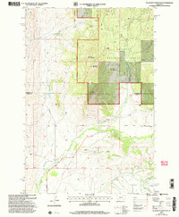
2000 Map of Scab Rock Mountain
USGS Topo · Published 2005About this map
The Gallatin National Forest dominates this high-altitude landscape along the border of Meagher and Park counties. Centered on the prominent summits of Scab Rock Mountain and Goat Mountain, the terrain is defined by a radial drainage system where headwaters like Sixteenmile Creek and Smith Creek carve deep valleys through the mountain front. The presence of the Livingston Ranger District reflects the federal management of these timber and watershed lands, while lower elevations to the south show the influence of early agricultural infrastructure. This is evidenced by the Camp Ditch and numerous irrigation points along the Shields River. A few scattered industrial markers, such as the Gravel Pit near Bear Gulch, indicate the localized extraction supporting the area's network of forest roads and trails during the late twentieth century.
Find a feature on this map
26 named features on this map. Tap any name to fly to it.
Don’t see what you’re looking for? This feature index may not catch every label — zoom into the map to look around manually.
Map Details
Editions of this 2000 Scab Rock Mountain Map
This is the sole edition of this map. No revisions or reprints were ever made.
Other maps of this area

1886 · Little Belt Mts.
USGS Topo · 1:250,000

1894 · Little Belt Mts.
USGS Topo · 1:250,000

1897 · Little Belt Mts.
USGS Topo · 1:250,000

1898 · Little Belt Mts.
USGS Topo · 1:250,000

1902 · Little Belt Mts.
USGS Topo · 1:250,000

1948 · White Sulphur Springs
USGS Topo · 1:250,000

1951 · Hamen
USGS Topo · 1:24,000
1951 · Wolf Hill
USGS Topo · 1:24,000

1951 · Rimrock Divide
USGS Topo · 1:24,000

1958 · White Sulphur Springs
USGS Topo · 1:250,000