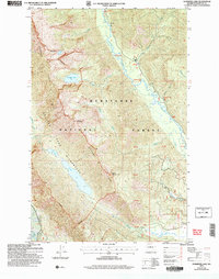
2004 Map of Schaffer Lake
USGS Topo · Published 2008About this map
Chiwawa River dominates the central valley of this landscape, its path creating a natural corridor between the high peaks of the Wenatchee National Forest. This 2004 revision, based on earlier surveys and modern imagery, details the high-elevation terrain of the Glacier Peak Wilderness, where prominent alpine features like Schaefer Lake and Twin Lakes are situated beneath the shadows of McCall Mountain and Crook Mountain. Along the river valley, the geography includes specific landforms such as Atkinson Flat and the Riverbend area. The drainage network is complex, fed by numerous tributaries including Meadow Creek, Raging Creek, and Minnow Creek, which flow off the steep western flanks of Chiwawa Ridge. The map serves as a detailed record of Forest Service management areas and wilderness boundaries in this part of Chelan County.
Find a feature on this map
22 named features on this map. Tap any name to fly to it.
Don’t see what you’re looking for? This feature index may not catch every label — zoom into the map to look around manually.
Map Details
Editions of this 2004 Schaffer Lake Map
This is the sole edition of this map. No revisions or reprints were ever made.
Other maps of this area

1901 · Chiwaukum
USGS Topo · 1:125,000

1902 · Stehekin
USGS Topo · 1:125,000

1904 · Stehekin
USGS Topo · 1:125,000

1904 · Chiwaukum
USGS Topo · 1:125,000

1944 · Holden
USGS Topo · 1:62,500

1944 · Lucerne
USGS Topo · 1:62,500

1949 · Lucerne
USGS Topo · 1:62,500

1949 · Holden
USGS Topo · 1:62,500

1955 · Concrete
USGS Topo · 1:250,000

1957 · Wenatchee
USGS Topo · 1:250,000