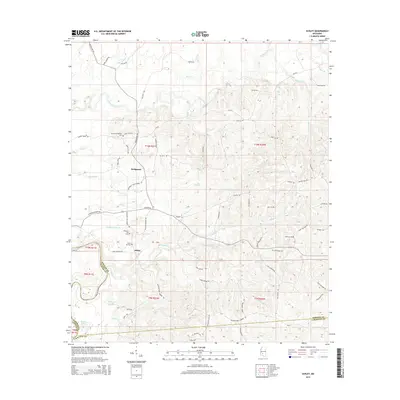
2015 Map of Schley
USGS Topo · Published 2015About this map
The Strong River and Pearl River define the intricate drainage patterns of this Simpson County landscape, where small family-named settlements like Bridgeport and Schley are connected by a web of rural roads. Numerous cemeteries, such as the Armstrong-Buckley Cem, Taylor Hill Cem, and Peacock Cem, serve as critical points of interest for genealogists and local historians, often marking the centers of early community life in this part of Mississippi. The terrain is marked by numerous creeks, including Vaughns Cr and Big Cr, which feed into the primary river systems. To the southwest, the landscape opens near Dickerson Lake and Martin Lake along the border with Copiah and Lawrence counties. This survey provides a clear view of the rural infrastructure, from the winding Shivers Rd to the established township and range lines that have shaped local property divisions for generations.
Find a feature on this map
78 named features on this map. Tap any name to fly to it.
Don’t see what you’re looking for? This feature index may not catch every label — zoom into the map to look around manually.
Map Details
Editions of this 2015 Schley Map
This is the sole edition of this map. No revisions or reprints were ever made.
Other maps of this area

1953 · Hattiesburg
USGS Topo · 1:250,000

1953 · Natchez
USGS Topo · 1:250,000

1956 · Natchez
USGS Topo · 1:250,000

1958 · Hattiesburg
USGS Topo · 1:250,000

1959 · Natchez
USGS Topo · 1:250,000
1970 · Hopewell
USGS Topo · 1:24,000
1970 · Harrisville
USGS Topo · 1:24,000
1970 · Mendenhall West
USGS Topo · 1:24,000

1970 · New Hebron
USGS Topo · 1:24,000

1971 · Schley
USGS Topo · 1:24,000