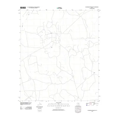
2010 Map of Schneeman Draw SW
USGS Topo · Published 2010About this map
Todd Deep Oil Field anchors the landscape of this portion of Crockett County, where industrial infrastructure and private ranching define the local geography. The territory is marked by the presence of significant landholdings such as Fields Ranch in the central region and Bean Ranch situated to the east. These family-named landmarks suggest a pattern of large-scale land use common in the Trans-Pecos region of Texas, where water features like Howard Draw dictate the orientation of access roads and rural homesteads.
Find a feature on this map
4 named features on this map. Tap any name to fly to it.
Don’t see what you’re looking for? This feature index may not catch every label — zoom into the map to look around manually.
Map Details
Editions of this 2010 Schneeman Draw SW Map
This is the sole edition of this map. No revisions or reprints were ever made.
Other maps of this area

1929 · Sheffield
USGS Topo · 1:125,000

1954 · Sonora
USGS Topo · 1:250,000

1958 · Sonora
USGS Topo · 1:250,000

1967 · Owens Creek SE
USGS Topo · 1:24,000

1967 · Owens Creek NE
USGS Topo · 1:24,000

1967 · Schneeman Draw NW
USGS Topo · 1:24,000
1967 · Schneeman Draw NE
USGS Topo · 1:24,000

1967 · Pikes Peak
USGS Topo · 1:24,000
1967 · Schneeman Draw SW
USGS Topo · 1:24,000

1967 · Bachelor Hill
USGS Topo · 1:24,000