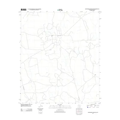
2012 Map of Schneeman Draw SW
USGS Topo · Published 2012About this map
Todd Deep Oil Field anchors the northern portion of this West Texas landscape, illustrating the deep-seated energy industry typical of the Edwards Plateau. The terrain is characterized by a network of ranching infrastructure and intermittent drainage patterns, with Fields Ranch and Bean Ranch serving as primary local landmarks. These named properties signify the long-standing ranching tradition in Crockett County, where large landholdings are connected by a sparse grid of rural thoroughfares. Transportation through this arid region is facilitated by Ranch Road 1964, Vic Montgomery Rd, and Pikes Peak Rd, which provide essential access for both the petroleum industry and local agricultural operations. The map reflects a modern era of land management where resource extraction and livestock ranching coexist within a vast, semi-arid environment.
Find a feature on this map
6 named features on this map. Tap any name to fly to it.
Don’t see what you’re looking for? This feature index may not catch every label — zoom into the map to look around manually.
Map Details
Editions of this 2012 Schneeman Draw SW Map
This is the sole edition of this map. No revisions or reprints were ever made.
Other maps of this area

1929 · Sheffield
USGS Topo · 1:125,000

1954 · Sonora
USGS Topo · 1:250,000

1958 · Sonora
USGS Topo · 1:250,000

1967 · Owens Creek SE
USGS Topo · 1:24,000

1967 · Owens Creek NE
USGS Topo · 1:24,000

1967 · Schneeman Draw NW
USGS Topo · 1:24,000
1967 · Schneeman Draw NE
USGS Topo · 1:24,000

1967 · Pikes Peak
USGS Topo · 1:24,000
1967 · Schneeman Draw SW
USGS Topo · 1:24,000

1967 · Bachelor Hill
USGS Topo · 1:24,000