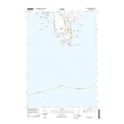
2014 Map of Schoodic Head
USGS Topo · Published 2014About this map
Acadia National Park dominates the coastal landscape of the Schoodic Peninsula in this 2014 survey. The terrain is characterized by prominent granite formations such as The Anvil and Schoodic Head, rising sharply above the Atlantic Ocean. The map details the complex shoreline of Hancock County, from the sheltered waters of Winter Harbor and Schoodic Harbor to the exposed ledge of Schoodic Point. Land use is defined by a mix of conservation and maritime access, with the Schoodic Scenic Bywy providing a modern corridor through the park's eastern section. Notable landmarks include the Ravens Nest cliffs and a cluster of islands including Big Moose Island, Turtle Island, and Mark Island, illustrating the jagged, glaciated nature of the Maine coast in the early 21st century.
Find a feature on this map
42 named features on this map. Tap any name to fly to it.
Don’t see what you’re looking for? This feature index may not catch every label — zoom into the map to look around manually.
Map Details
Editions of this 2014 Schoodic Head Map
This is the sole edition of this map. No revisions or reprints were ever made.
Other maps of this area

1904 · Bar Harbor
USGS Topo · 1:62,500

1904 · Petit Manan
USGS Topo · 1:62,500

1942 · Bar Harbor
USGS Topo · 1:62,500

1948 · Bangor
USGS Topo · 1:250,000
1948 · Petit Manan
USGS Topo · 1:24,000
1950 · Petit Manan
USGS Topo · 1:24,000
1950 · Petit Manan
USGS Topo · 1:24,000

1956 · Bar Harbor
USGS Topo · 1:62,500

1956 · Bangor
USGS Topo · 1:250,000

1960 · Bangor
USGS Topo · 1:250,000