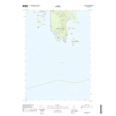
2021 Map of Schoodic Head
USGS Topo · Published 2021About this map
Acadia National Park dominates the rugged coastal landscape of the Schoodic Peninsula in this 2021 study. The terrain is defined by dramatic coastal elevations such as Schoodic Head, Buck Cove Mtn, and the distinctive formation known as The Anvil. A complex network of trails and paths, including the Anvil Trl and Buck Cove Mountain Trl, underscores the area's modern role as a protected recreational corridor.
Find a feature on this map
46 named features on this map. Tap any name to fly to it.
Don’t see what you’re looking for? This feature index may not catch every label — zoom into the map to look around manually.
Map Details
Editions of this 2021 Schoodic Head Map
This is the sole edition of this map. No revisions or reprints were ever made.
Other maps of this area

1904 · Bar Harbor
USGS Topo · 1:62,500

1904 · Petit Manan
USGS Topo · 1:62,500

1942 · Bar Harbor
USGS Topo · 1:62,500

1948 · Bangor
USGS Topo · 1:250,000
1948 · Petit Manan
USGS Topo · 1:24,000
1950 · Petit Manan
USGS Topo · 1:24,000
1950 · Petit Manan
USGS Topo · 1:24,000

1956 · Bar Harbor
USGS Topo · 1:62,500

1956 · Bangor
USGS Topo · 1:250,000

1960 · Bangor
USGS Topo · 1:250,000