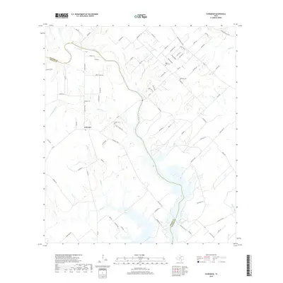
2019 Map of Schroeder
USGS Topo · Published 2019About this map
Schroeder serves as the central settlement on this coastal plain landscape where Goliad and Victoria counties meet. The terrain is defined by a dense network of seasonal drainages, including Hog Thief Cr and Gobbler Cr, which feed into the wider reaches of Coleto Creek. This region’s heritage is marked by its numerous rural burial grounds, such as Mission Valley Cem and the sequestered Mistletoe Cem, providing specific points of interest for genealogists tracing early families in this part of South Texas. A system of farm-to-market roads and named lanes like Spanish Grant Rd and Kolodzey Rd connect the scattered homesteads and ranching properties. The map captures the area's rural character, showing a community structured around these waterways and the historic land divisions that shaped local development.
Find a feature on this map
80 named features on this map. Tap any name to fly to it.
Don’t see what you’re looking for? This feature index may not catch every label — zoom into the map to look around manually.
Map Details
Editions of this 2019 Schroeder Map
This is the sole edition of this map. No revisions or reprints were ever made.
Other maps of this area

1953 · Beeville
USGS Topo · 1:250,000

1956 · Beeville
USGS Topo · 1:250,000

1960 · Beeville
USGS Topo · 1:250,000

1962 · Fannin
USGS Topo · 1:24,000

1962 · Hensley Lake
USGS Topo · 1:24,000

1962 · Raisin
USGS Topo · 1:24,000

1963 · Meyersville
USGS Topo · 1:24,000

1963 · Nursery
USGS Topo · 1:24,000
1963 · Mission Valley
USGS Topo · 1:24,000
1963 · Ander
USGS Topo · 1:24,000