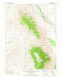
1964 Map of Schurz
USGS Topo · Published 1966About this map
The settlement of Schurz sits at the northern end of the Wassuk Range, serving as a central hub for the Walker River Indian Reservation in the mid-1960s. The landscape is defined by the stark contrast between the riparian corridor of the Walker River and the high peaks of Black Mountain and Bald Mountain. Industry and infrastructure are marked by the presence of the Southern Pacific railroad and mining interests such as the Northern Lights Mine and Sunny Slope Mine. Significant local facilities including a Hospital, a Landing Field, and a Radio Facility indicate the area's role as a regional service center during this era. Numerous water sources, from the northern Paiute Spring to southern canyons like Deadman Canyon, reveal the critical importance of spring-fed hydrology in this high-desert environment, eventually draining toward the shores of Walker Lake.
Find a feature on this map
31 named features on this map. Tap any name to fly to it.
Don’t see what you’re looking for? This feature index may not catch every label — zoom into the map to look around manually.
Map Details
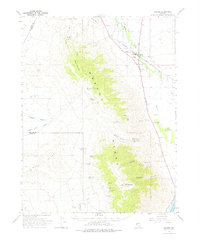
Editions of this 1964 Schurz Map
2 editions found
Other maps of this area

1891 · Wabuska
USGS Topo · 1:125,000

1891 · Wellington
USGS Topo · 1:125,000

1893 · Wellington
USGS Topo · 1:125,000

1894 · Wabuska
USGS Topo · 1:125,000

1908 · Carson Sink
USGS Topo · 1:250,000

1909 · Hawthorne
USGS Topo · 1:250,000

1910 · Carson Sink
USGS Topo · 1:250,000

1911 · Hawthorne
USGS Topo · 1:250,000

1915 · Hawthorne
USGS Topo · 1:250,000

1948 · Walker Lake
USGS Topo · 1:250,000