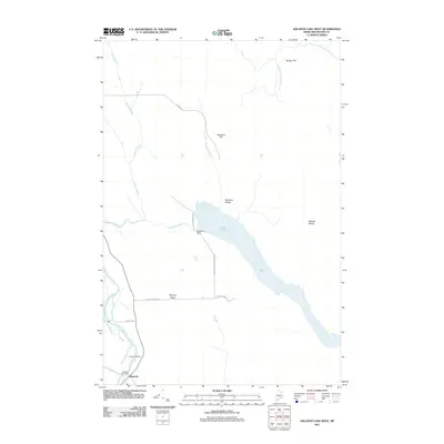
2011 Map of Scopan Lake West
USGS Topo · Published 2011About this map
Masardis serves as the primary hub of this Aroostook County landscape, situated along the Aroostook River in the southwestern corner. The geography is defined by the massive reach of Scopan Lake, controlled by the Squapan Dam at its western narrow. The map documents a rural timber and transport network, evidenced by specialized infrastructure like Nowland Siding and Midway Siding alongside several family-named landmarks. Interior access is dictated by logging and utility routes such as Private Maine Public Srv Rd and Heartbreak Ridge Rd, which cut through the forested terrain near Sterling Ridge. For genealogists and local historians, the presence of the Masardis Post Office and the Smith Cemetery near the river provides concrete touchpoints for tracing 19th and 20th-century family roots in this northern Maine township.
Find a feature on this map
20 named features on this map. Tap any name to fly to it.
Don’t see what you’re looking for? This feature index may not catch every label — zoom into the map to look around manually.
Map Details
Editions of this 2011 Scopan Lake West Map
This is the sole edition of this map. No revisions or reprints were ever made.
Other maps of this area

1931 · Ashland
USGS Topo · 1:48,000

1934 · Ashland
USGS Topo · 1:62,500

1935 · Howe Brook
USGS Topo · 1:48,000

1935 · Presque Isle
USGS Topo · 1:62,500

1939 · Howe Brook
USGS Topo · 1:62,500

1940 · Oxbow
USGS Topo · 1:62,500

1942 · Oxbow
USGS Topo · 1:62,500

1953 · Ashland
USGS Topo · 1:62,500

1953 · Presque Isle
USGS Topo · 1:62,500

1954 · Howe Brook
USGS Topo · 1:62,500